

Another things is do the lines that feed the Pyramids pass other ancient site to the north of south of there, that will be something to chase up, ZZZZZzzzzzzz Im dropping off folks.
Pyramids
Pyramids
Tonight I dowsed the Pyramids in greater detail to see if the wide paths of energy lines running just east of Table Mountain cross the Pyramids, and in my opinion they dont.The three Pyramids all are built on sacred ground, but the energy lines while powerful are small and in some cases only 5.55 feet wide running north to south there, in fact the Great Pyramid has a wider path west to east than its north to south one.This will give the site an anti clockwise motion of lines, you will find it best to walk the site anti clockwise, as this will allow you to move with the earth forces there, walking the other way will seem like hard work, AND you will not enjoy the experience as much, since you are in tune with its earth forces on site.The energy lines here do not cross the area of the Valley Of Kings to the south, I though they might, as the Kings would have then shared with the Pyramids the path to Sirius perhaps along the energy paths ? I never dowsed for the Hall of Records said to be hidden on site, thats for another day, my bed is calling me. 
Another things is do the lines that feed the Pyramids pass other ancient site to the north of south of there, that will be something to chase up, ZZZZZzzzzzzz Im dropping off folks.
Another things is do the lines that feed the Pyramids pass other ancient site to the north of south of there, that will be something to chase up, ZZZZZzzzzzzz Im dropping off folks.
Re: Pyramids
If you follow the west to east path of energy lines that flow through the Great Pyramid, they pass through the Mard/Marid Castles in Saudi Arabia, and here close to this complex are three sacred sites of high influence, its a very special place thats for sure..I dont know what may be further east following the West Pyramid energy line, but I imagine yet more special places of worship, the same Im sure if you follow any of the other energy lines that pass through the Great Pyramid.When you think of it, most if not all energy lines must share at some point ancient sites of great age, thus linking them to the stories and deeds that took place there in the past, places where history is absorbed and part of the energy lines....Try and look further later in other directions, to see if more links in with the Great Pyramid,those coming from the north will Im sure touch ancient sites of old, while the energy lines are only single or double lines at the Great Pyramid, they carry powerful influence world wide.Picking up the sacred power at perhaps more than just one site, like a number of batterys all connected together.
Re: Pyramids
The north to south path of energy lines that cross the Great Pyramid do not seem to pass or cross any ancient sites that I can see, they push upwards through Russia/Ukraine and go north.While the south energy line goes through Africa to Swaziland and leave the country close to Durban, when I thought this path might have passed or crossed the Cradle Of Man close to Joburg, oh well.
-
Ronnie Gallagher
- Newbie

- Posts: 7
- Joined: Mon May 16, 2011 8:09 am
Re: Pyramids
Mike
Using Google Earth and pyramid peaks check out these alignments:
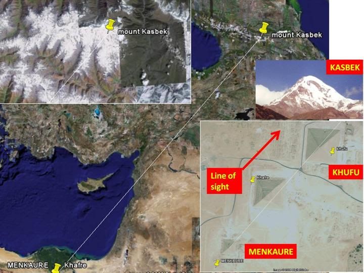
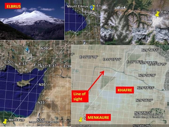
· Menkaure Pyramid – Khafre Pyramid – Mt Elbrus in Caucasus
· Menkaure Pyramid – Khufu Pyramid – Mt Kasbek
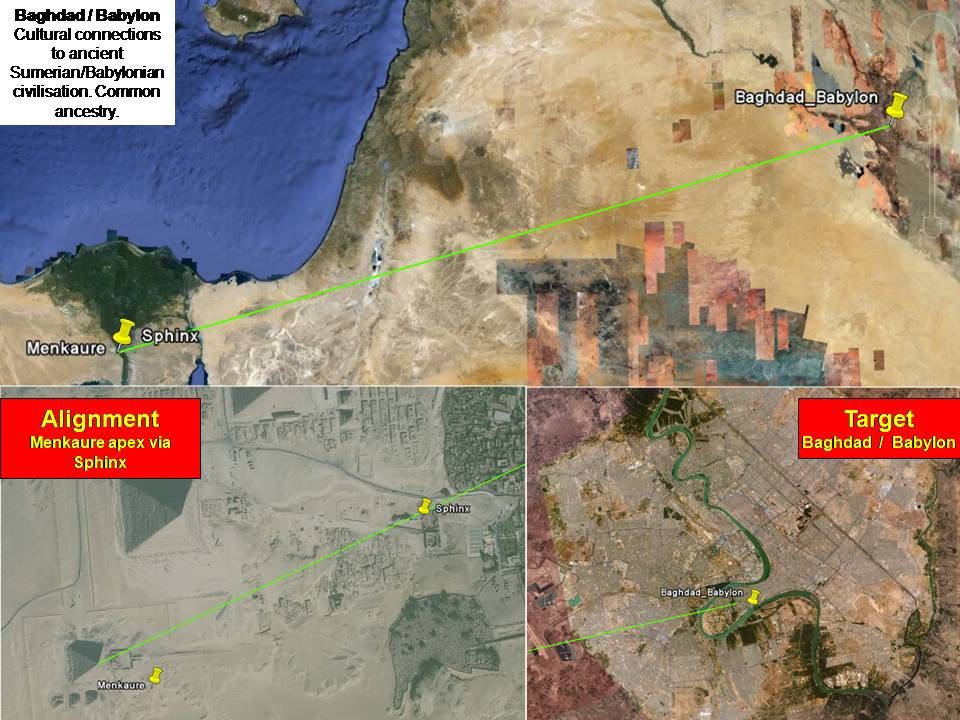
· Menkaure Pyramid – Sphinx – Baghdad (ancient Babylon )
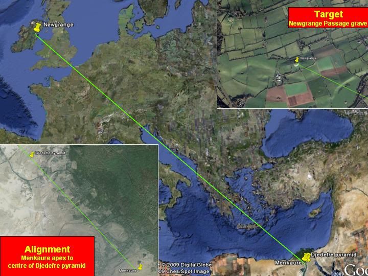
· Menkaure Pyramid – Djedefre Pyramid – Newgrange
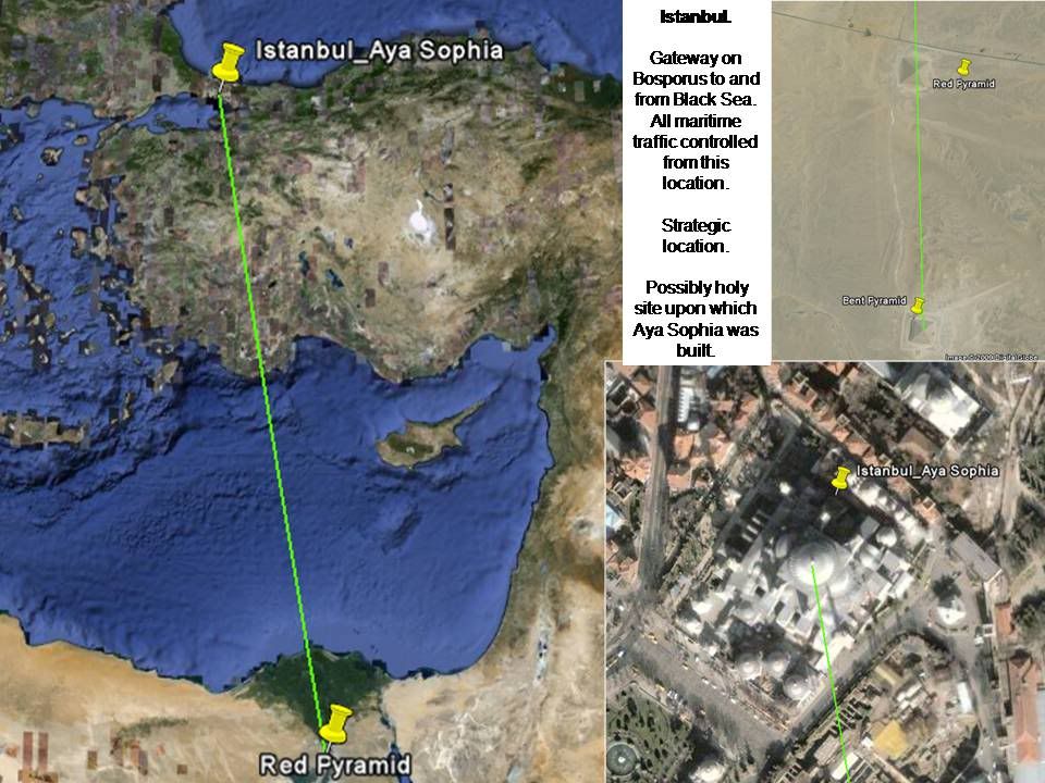
· Bent Pyramid – Red Pyramid – Istanbul
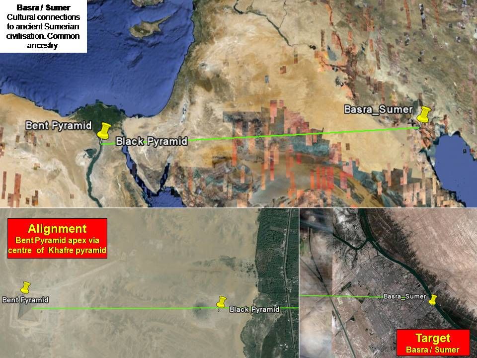
· Bent Pyramid – Black Pyramid – Basra (ancient Sumer ).
Are these just remarkable coincidences or are the pyramid builders using the alignments as signposts to significant prehistory locations?
Ronnie
Using Google Earth and pyramid peaks check out these alignments:
· Menkaure Pyramid – Khafre Pyramid – Mt Elbrus in Caucasus
· Menkaure Pyramid – Khufu Pyramid – Mt Kasbek
· Menkaure Pyramid – Sphinx – Baghdad (ancient Babylon )
· Menkaure Pyramid – Djedefre Pyramid – Newgrange
· Bent Pyramid – Red Pyramid – Istanbul
· Bent Pyramid – Black Pyramid – Basra (ancient Sumer ).
Are these just remarkable coincidences or are the pyramid builders using the alignments as signposts to significant prehistory locations?
Ronnie
-
Ronnie Gallagher
- Newbie
- Posts: 7
- Joined: Mon May 16, 2011 8:09 am
Re: Pyramids
(mod - photo links activated - GG)
Mike.
Links to slides below:
I am in full agreement that the Giza plateau has to be 'sacred land' and may well have earth energy associations. However, also intriguing are a series of apparent alignments involving the pyramids. Alignments can be found which may or may not be real, however in the context of inferred ancient cultural connections, those highlighted statistically go beyond coincidence. And with Menkaure as a starting point and 'sighting' over nearby, in-view monuments, this makes the alignment idea even more significant. It is as if the pyramids were constructed (in part) and positioned as signposts to important locations. If so this is a mindboggling achievement and testimony to their technical and scientific abilities.
So, if the pyramid builders constructed their monuments with deliberate intent and to send a message down through the ages, what might it mean?
Leyline hunters and dowsers may wish to consider this question.
Ronnie


-
ledgehammer

- Competent

- Posts: 500
- Joined: Wed Dec 29, 2010 7:49 pm
Re: Pyramids
Ronnie,
Pardon my question but what do you consider an alignment?
Tom
Pardon my question but what do you consider an alignment?
Tom
The universe is a soul, trying to understand itself.... We each have the power to look inward at its immense beauty....
Re: Pyramids
Hi Ronnie,
I like the idea, and in some cases your links do match sites that are very old and historic, but I cannot find this with them all, I shall have another look later but I can see where your coming from..The ones that work for me I shall follow the line to see where it leads, as I have found this often picks out sacred sites with little or no records of, long forgoten places of wonder and magic that are now ruins or just open ground.
I like the idea, and in some cases your links do match sites that are very old and historic, but I cannot find this with them all, I shall have another look later but I can see where your coming from..The ones that work for me I shall follow the line to see where it leads, as I have found this often picks out sacred sites with little or no records of, long forgoten places of wonder and magic that are now ruins or just open ground.
-
Ronnie Gallagher
- Newbie
- Posts: 7
- Joined: Mon May 16, 2011 8:09 am
Re: Pyramids
Tom.
See my previous post, - (above the picture links).
Mike.
By way of explanation, I've been researching the Caucasus/Azerbaijan region for some time now and made lots of weird observations that suggest very ancient lnks to the Nile Valley, Giza and the Near East. The paper below by Sir William Flinders Petrie explains a possible Egyptian ancestry in the Caucasus. My research involves evidence of flooding as seen in raised terraces and strandlines. For example:
Highest strandline at ca +225m. Soft Valley floor and unlikely of any great geological age, otherwise erosional process would destroy them.
See: http://s287.photobucket.com/albums/ll13 ... lide20.jpg
and
Terraces at +26m, +130m and +167m. Evidence of prolonged inundation. These are not due to tectonic uplift.
http://s287.photobucket.com/albums/ll13 ... _small.jpg
The implicatiion from these is that Eurasian geography was very different during and at the end of the Ice Age. Even into the Holocene period I suspect a late onset marine flood happened raising the caspian Sea again to a point where it overflowed to the Black Sea. Essentially, other younger strandlines suggest people could navigate from Central Asia through to the Mediterranean. As the waterfist reflooded around 9000 years ago and then fell back at arounf 6000 years ago I suspect people migrated to safer climes. So. if there is a common heritage to Mesopotamia, and navigation is involved, then this might help explain the alignments I've shown to early civilisations. Of course it might be pyramidiocy, but the alignments are intriguing. And if they are elaborate and indelible signposts then earth energies may not be involved.
Cheers
Ronnie
THE ORIGINS OF THE BOOK OF THE DEAD.
To understand the mythologic literature of Egypt it is needful to have regard to the many sources of population, each of which has in turn probably added to the heterogeneous mass of myths that is seen in the historic times, One great group of myths, known the Pyramid Texts, is particularly the royal religion, identified with the line of kings in the Vth dynasty, and knows nothing of the geography of the Book of the Dead; as it contains much of remote savagery in its composition, it has clearly been brought in with ancient tribal traditions. On the other hand, the Book of the Dead is the popular mythology, cherished by the majority down to the end of paganism, yet containing much that is very primitive embedded in its structure. Until we obtain a firm outline of the various tribal movements and invasions of prehistoric times, we cannot hope to analyse the confusion of the mythology. There is good hope that, by advancing the study of the varied civilisations side by side with that of the mythology, each may serve to elucidate the other.
The discovery of the Badarian civilisation has greatly changed our ideas of the early history. We are in the presence of an advanced culture, apparently imported, and decaying in Egypt. There is the probability that it came from Asia and connections point to the Caucasus region. This is a very old idea, as Herodotus comments on the traditional connection of the Colchians with Egyptians, and states that in his time they were still alike in customs, way of living, and language. Now, in the Book of the Dead, as Prof. Fessenden has pointed out, a most striking peculiarity is the frequent mention of lakes of fire, not as places of horror, but in the midst of the paradise of cultivation, yet also and high mountains. Such incongruous conditions are not often to be found; they cannot have been suggested by Egypt itself, but certainly belong to some distant region, and the nearest country with such features is the Caucasus, with its oil springs in the midst of the most fertile valley surrounded by barren mountains.
The suggestion that the Book of the Dead embodied traditions of the Caucasus region has been noted already in this journal (1924, p. 124). Such a possibility is so important, that it is worth close examination to see whether the evidence is systematic, or is only an accidental resemblance. There are some geographical indications to be gathered in these traditions, places being described as east or west, north or south, up or down stream. So long as the whole descriptions are referred to mere imaginations of a spiritual world, the details have been neglected. But if the possibility of a tradition being based on real localities is considered, then the descriptions should be carefully observed. During the present misfortunes in the region of the Caucasus, it is impossible to examine the early civilisations there; all that can be done is to take the evidence of names, so as to prepare the way for testing the conclusions on the actual ground at some future time.
The suitability of such a region for civilisation is attested by Strabo (XI, iv, 3); he describes Albania, the lower part of the valley of the Kur, as producing " every kind of fruit, even the most delicate, and every kind of plant and evergreen; . . . all that is excellent grows without sowing, and without plowing……In many places the ground, which has been sowed once, produces two or three crops, the first of which is even fifty-fold, and that without a fallow . . . The whole plain is better watered than Babylon or Egypt, by rivers and streams, so that it always presents the appearance of heritage. The young trees bear fruit even in the second year, but the full groove yield so much that a large quantity of it is left on the branches. The cattle both tame and wild thrive well in this country. The men are distinguished for beauty of person and for size." In modern times Maurier, in his guide Guide au Caucase (1894), mentions maize as the main crop, growing seven to ten feet high, and bearing eight hundred-fold. Flax has been an immemorial crop in Mingrelia. These descriptions accord with the fertile Egyptian paradise, with flowing streams and growing corn seven cubits high. The temperature in the winter is that of the south of England in the summer it is like that of northern Lombardy.
In looking at the Egyptian traditions, the natural condition of a people who have emigrated must be taken into account. The Norse entering Britain planted the names of their gods in many places; they adopted these places the new homes of their mythology. In modern times, emigrants use names from their old country in new conditions. In the United States there are two or three dozen of each of the names of our principal cities. The spoken form of a name may be commoner than the real form. There are seven Sandfords in England, only one in America, alongside of nineteen Sanfords there. Further, when migrating people are without writing they depend entirely on the spoken names, and when, in later time, the names begin to be written, it is natural for them to be expressed by rebus words, which have nothing to do with the sense, but only show the sound. An unlettered Englishman might address a letter to Livorno by drawing a leg and a horn. It is obvious that the Egyptian form of writing an imported name may appear quite Egyptian in its dress, and yet be a verbal representation of its original sound.
In order to test the possible connection of Egyptians with the Caucasus, all the geographical terms of direction associated with place-names must be noted; the names must then be searched for in the Caucuses in the same relative connection, as this greatly limits the range, and so gives further likelihood to such similarities of name as may pass this test. The results of this comparison stated on the accompanying map; the names in capitals are those in the Book of the Dead, those in small type are the classical forms in Ptolemy's Geography, those in italics are the modern names.
One of the most important names is that of the kingdom of Osiris (ch. xviii, cxxvii) or Un-Nefer (ch. xv), called AKRET or IKRET. This is closely like the Greek name of a region in the upper part of the main river, Ekretike, the modern Kartlia; [see note below].
The “Pillars of Shu" were prominent hills over which the sun rose (ch. cix of Nu), therefore somewhere east of the kingdom of AKRET. The gate ZESERT (=TOSORT, Gr) is the gate of the pillars of Shu (ch. xvii), and therefore also east of AKRET; in that relation we se the district of Tosarene.
Near ZESERT lay the most fertile plain of the fields of AĂRU or IĂRU, and thus near Tosarene is the river lora through the midst of Transcaucasia. This river has others on either side of it which receive the mountain torrents, while it only drains a fertile plain free of violent changes, In a Trip through the Eastern Caucasus, 1889, the Hon. John (later Lord) Abercromby describes the level cultivated plains traversed by tile Iora; again, a splendid open grassy space, with abundance of wood and water at an elevation (of 3,600 feet above the sea, with the Iora, and beyond it more wooded hills. The blessed Fields of the Iaru yet had a lake of fire in them, and on the Iora is a great naphtha spring, marked ‘N’ on this map.
The fields of Iaru are described as behind, or at the back of the head of KÄ‚RU (ch. xvii), and the waters of the Iora start from the mountain at the head of the Kur river. The description rather suggests looking at this region from the Colchis side.
http://s287.photobucket.com/albums/ll13 ... uacsus.jpg
From AKRET the Egyptian sailed down the river (ch. xv) to DADU or TATTU; so, descending from Ekretike, the region of Tot, Totene, is reached, half-way to the river mouth.
Further on, it is said, the eastern gate of heaven had on its south the lake of KHALUSA (NU, ch. cix); so at the eastern end of the valley, on the south side, was Kholuata, now lake Chalasi.
We read that that RESTAU is the DUAT region (ch. xvii) - they are identical. The DUAT had its north gate at ZESERT, Tosarene, and so lay south of that, and in the south-east is Resht, agreeing to the name of RESTAU.
To the north of the fields of IARU was the river REU (ch. cxlix) ; and at the north of the Caucasus is the great river Rha, the Volga.
BAKHAU is often named; it was a great mountain upon which heaven rested, 9½ by 6½ miles in size, which seems like a real estimate. It was the "Mount Bakhau of the rising sun " (ch. clxxii, Nebseni): the name seems connected with beka, “the dawnâ€." Baku at the eastern end of the Caucasus range agrees with this position.
At the other end of the day was the land of sunset, TAMANU (ch. xv, D.6,12; E. 15). The western end of the Caucasus range is the Taman peninsula.
So far, we are dealing with places whose position is stated in relation to each other, and which therefore support each other in identification. Other places may less certainly be identified, by the names in a suitable position, but not directly connected one with another.
Homage is paid to the divinity of the stars in AUN or 0N, which lay to the west (ch. lxxxv), and the god Annu in ANDES (ch. xv). The stars of the gods are specially the undying ones in the north, and looking north from Ekretike there is the city Oni, and the mountains of Andish. The “divine door of the city of BTA" may possibly be the city of Ptua near Totene.
ANRUDEE, "it does not increases'' the barren region, had DUAT and RESTAU to the south of it (ch. xvii). It seems likely that it was the Caucasus mountain range.
There was a lake of fire in that region near the SHENY dwelling (ch. xvii); at the foot of the mountains in Sanua.
Not far from this is Mosega, and this might be MESQTO, which was a place of purification, probably by fire (ch. cxxii, clxxvi).
ASTES is reached after ANRUDEF (ch. cxlvi), probably the same as ASSET, which is said to be too remote to be seen (ch. cxlix). Both descriptions would agree to the northern place Ashti.
DESDES was the lake over which the sun set (ch. XV)) and repeatedly it is claimed that this lake is at peace. 'The name is literally “the choppyâ€; from the position, it would refer to the Black Sea, and the prevalent west wind would make it rough on the eastern coast.
MAOATI was a lake, of which the heads, or sources, were known (ch. xvii). It is singularly like the name of the lake of Maiotis, or Sea of Azov.
The FENKU were a people who gave gifts, which were buried on the shore of the lake MAOATI (ch. cxxv), and they were therefore in its region. This suggests a possible link with Phanagoria at the mouth of Maiotis.
In chapter cx there are three lakes drawn, named URMU, QETQETMU, and HETEPMU, or the “greatâ€, the “moving†and the “peaceful" lakes. The name URMU may be linked with Urmia, the large lake south of the Caucasus; if so, the moving and quiet lakes might be lakes Van and Sevan.
This list accounts for most of the important names of places in the mythology of the Book of the Dead. Names, however, are very risky material on which to base conclusions; no doubt almost any name may have one or more parallels somewhere in the world, yet here we are dealing with a single region, and the names fall into place in accord with the indications of direction one from another. It seems very improbable that in so limited a field, already indicated by the physical description, more than a dozen names should so closely correspond, without having a real connection.
If this localisation should be accepted, it will have much influence on our understanding of the early religion. We may begin to analyse the Book of the Dead into the Caucasian and Nilotic sections. Osiris, repeatedly named as ruler of Akret, will thus be linked to the earliest stratum, and be of northern origin. Byblos may then have been an Osiris sanctuary during the migration through Syria. The strange mention of Sebek at Bakhau looks like some transference of Egyptian ideas. Possibly, the Zeus named by Strabo was Zeus Sabasios of Asia Minor, and so the name Sabas might have been transformed to Sebek on going to Egypt.
The mediaeval history of the kingdom of Akret or Ekretike may be here noted, from Telfer’s Crimea and Transcaucasia (1876). The position of Ekretike is that of the modern Imeritia, which kingdom was formerly called Egris (ii, 30). from Egros, son of Thargamos (Togarmah). This Egros seems to be equivalent in another dialect to Karthlos, son of Thargamos (i, 172). From him is named Mount Karthlos and the rivulet Karthly (i, 162, 172). Evidently this district was the great kingdom of the country (see i, 176; ii, 33), with a long tradition of its early importance, which we can now perceive far back in the beginnings of civilisation.
In looking at a remote origin for the popular mythology of Egypt, we must remember the persistence of folk-tales and their long antiquity. They are cherished as religious literature even when of secular origin, such as the Tibetan sacred books, which are the racy and vivid stories of north Indian life during the Asoka period. When only transmitted by word of mouths they can survive for thousands of years, like the Eskimo tales which are verbally the same on the Atlantic and Alaska, though the people rarely know anything more than a day's journey from their own centre. The maintenance of a detailed record of history goes back for many centuries in the African kingdoms, and the Polynesians (in spite of being so scattered) have kept in memory their migrations and colonising of New Zealand. There is, therefore, no improbability in place-names which have been embodied in mythology being preserved for very long periods.
It appears, then, that the cultural connections of the earliest Egyptians, as well as the physical descriptions in their mythology, point to the Caucasus region. When, further, we find there the names of the principal places of the mythology in their relative positions, it gives strong grounds for regarding that region as the homeland of the earliest civilisation of the Egyptians.
FLINDERS PETRIE.
‘Ancient Egypt’, June 1926.
Table of Place Names mentioned by Flinders Petrie on Map.(RG)
Book of the Dead Ptolemy’s Geography
AKRET Ekretike (river)
ANDES Andish (mountain)
ASTES Ashti
BAKHAU Baku
BTA Ptua
DEDU / TATTU
Tot / Totene
FENKHU Phanagoria
IARU Iora (river)
KARA Kur
KHALUSA Kholuata
MAOATI Maiotis
MESQTO Mosega
ON Oni
RESTAU Resht
REU Rha (river)
SHENY Sanua
TAMANU Taman
URMU Urmia
ZESERT Tosarene
-
ledgehammer
- Competent
- Posts: 500
- Joined: Wed Dec 29, 2010 7:49 pm
Re: Pyramids
Ronnie,
These alignments are comprised of just three points, and/or is it possible they could be extended to enclose more?
Tom
These alignments are comprised of just three points, and/or is it possible they could be extended to enclose more?
Tom
The universe is a soul, trying to understand itself.... We each have the power to look inward at its immense beauty....
-
Ronnie Gallagher
- Newbie
- Posts: 7
- Joined: Mon May 16, 2011 8:09 am
Re: Pyramids
Tom.
Sorry . No I have not looked for intermediate points. The assumption is that the Egyptians had a formidable grasp of navigation, astronomy, geometry and geography. Knowing where places (targets) were on the globe they would only need to know their location to set a starting point (e.g. Menkaure's pyramid) and a line of sight Khufu/Khafre/Sphinx or Djedefre. There is no need for a fourth or other intermediate points.
I've not looked for any energy lines associated with AE. But like megalithic Britain I imagine that energy lines may exist associated with sacred places.
With regard to 'energy lines' in my research there is one alignment with many intermediate points that might be worth looking at. This is the line of the Caucasus Mountain Range. The reason it is significant is to do with orientation and astronomy. The mountain range is oriented 23.5 degrees in a NW to SE direction. Coincidentally the Earth is also tilted at the same angle. What this means is that at the Winter Solstice the sun rises in line from Baku to the SE, while at the Summer Solstice sunset, it sets into the Sea of Azov at Taman to the NW. This observation would be of great significance to ancient astronomers, and could well be an energy line. Its also I believe the reason why in Flinders Petrie's account of the Orign of the Book of the Dead that he observes that the sun rises over Bakhau ( Baku) and sets over Tamanu (the Taman peninsula).
From a dowsing perspective there are a few locations on this line that should be looked at. These are Mt. Barmak ( which I supect is the Mount Bakhau of the Rising Sun - its along story), and two enigmatic and mysterious monuments: the Maiden Tower (Gys Gilasi) and the Fairy Castle (Peri Gala). I've written about the latter two in the Azerbaijan International Magazine at:
Baku's Maiden Tower: And the Relationship to Winter Solstice Autumn 2006 (14.3)
http://azer.com/aiweb/categories/magazi ... index.html
Peri Gala: Mystery Surrounds "Fairy Castle" Autumn 2005 (13.3)
http://azer.com/aiweb/categories/magazi ... agher.html
The GPS coordinates are:
Mt. Barmak (Besh Barmak): 40°57'30.35"N 49°13'56.96"E
Maiden Tower: 40°21'58.07"N 49°50'14.47"E
Fairy Castle: 41°35'29.80"N 46°46'19.20"E
I suspect that dowsing Mt. Barmak might result in some interesting results as it is a site of pilgrimage and has several legends and myths associated with it. I'd be interested to hear from the dowsing community on this.
Regarding the Fairy Castle, this is an extremely interesting site that I'm continuing to research. Its also perhaps the target of the most significant alignment of all, as it exactly lines up with the two great pyramids of Khafre and Khufu. See:
Peri Gala alignment http://s287.photobucket.com/albums/ll13 ... gnment.jpg
Overall I've detected 16 alignments which in the context of an ancient homeland, migration and cultural connection theory, may be genuine. Obviously more research on some of the targets is needed. Statistically, the alignments found seem to be very improbable: it may all turn out to be a bizarre set of coincidences, but I think not.
For conspiracy theorists (and I'm not one), it was pointed out to me that the alignments may offer another insight into an ancient and odd image found on the Dollar bill: http://s287.photobucket.com/albums/ll13 ... gel_hq.jpg. Interesting!
Ronnie
Sorry . No I have not looked for intermediate points. The assumption is that the Egyptians had a formidable grasp of navigation, astronomy, geometry and geography. Knowing where places (targets) were on the globe they would only need to know their location to set a starting point (e.g. Menkaure's pyramid) and a line of sight Khufu/Khafre/Sphinx or Djedefre. There is no need for a fourth or other intermediate points.
I've not looked for any energy lines associated with AE. But like megalithic Britain I imagine that energy lines may exist associated with sacred places.
With regard to 'energy lines' in my research there is one alignment with many intermediate points that might be worth looking at. This is the line of the Caucasus Mountain Range. The reason it is significant is to do with orientation and astronomy. The mountain range is oriented 23.5 degrees in a NW to SE direction. Coincidentally the Earth is also tilted at the same angle. What this means is that at the Winter Solstice the sun rises in line from Baku to the SE, while at the Summer Solstice sunset, it sets into the Sea of Azov at Taman to the NW. This observation would be of great significance to ancient astronomers, and could well be an energy line. Its also I believe the reason why in Flinders Petrie's account of the Orign of the Book of the Dead that he observes that the sun rises over Bakhau ( Baku) and sets over Tamanu (the Taman peninsula).
This allusion may refer to the suns path across the sky on both a daily and annual basis. As such, if the Caucasus was a 'homeland' then there would be a number of significant locations, e.g. Baku, Taman. Mt Kasbek sits above the only route through the middle of the mountain range.BAKHAU is often named; it was a great mountain upon which heaven rested, 9½ by 6½ miles in size, which seems like a real estimate. It was the "Mount Bakhau of the rising sun " (ch. clxxii, Nebseni): the name seems connected with beka, “the dawnâ€." Baku at the eastern end of the Caucasus range agrees with this position.
At the other end of the day was the land of sunset, TAMANU (ch. xv, D.6,12; E. 15). The western end of the Caucasus range is the Taman peninsula.
From a dowsing perspective there are a few locations on this line that should be looked at. These are Mt. Barmak ( which I supect is the Mount Bakhau of the Rising Sun - its along story), and two enigmatic and mysterious monuments: the Maiden Tower (Gys Gilasi) and the Fairy Castle (Peri Gala). I've written about the latter two in the Azerbaijan International Magazine at:
Baku's Maiden Tower: And the Relationship to Winter Solstice Autumn 2006 (14.3)
http://azer.com/aiweb/categories/magazi ... index.html
Peri Gala: Mystery Surrounds "Fairy Castle" Autumn 2005 (13.3)
http://azer.com/aiweb/categories/magazi ... agher.html
The GPS coordinates are:
Mt. Barmak (Besh Barmak): 40°57'30.35"N 49°13'56.96"E
Maiden Tower: 40°21'58.07"N 49°50'14.47"E
Fairy Castle: 41°35'29.80"N 46°46'19.20"E
I suspect that dowsing Mt. Barmak might result in some interesting results as it is a site of pilgrimage and has several legends and myths associated with it. I'd be interested to hear from the dowsing community on this.
Regarding the Fairy Castle, this is an extremely interesting site that I'm continuing to research. Its also perhaps the target of the most significant alignment of all, as it exactly lines up with the two great pyramids of Khafre and Khufu. See:
Peri Gala alignment http://s287.photobucket.com/albums/ll13 ... gnment.jpg
Overall I've detected 16 alignments which in the context of an ancient homeland, migration and cultural connection theory, may be genuine. Obviously more research on some of the targets is needed. Statistically, the alignments found seem to be very improbable: it may all turn out to be a bizarre set of coincidences, but I think not.
For conspiracy theorists (and I'm not one), it was pointed out to me that the alignments may offer another insight into an ancient and odd image found on the Dollar bill: http://s287.photobucket.com/albums/ll13 ... gel_hq.jpg. Interesting!
Ronnie
Coincidence is the word we use when we can't see the levers and pulleys.
Emma Bull
-
ledgehammer
- Competent
- Posts: 500
- Joined: Wed Dec 29, 2010 7:49 pm
Re: Pyramids
Ronnie,
http://www.guardian.co.uk/science/2010/ ... woolworths
I find that often an alignment (four or more) has associated energy lines attached, This Caduceus (rod of Hermes) defines this concept perfectly If you find that a male and female energy line "snake" the alignment, a statue of Hermes incidently can be found on an energy current at somerleyton hall for what seems to be no other purpose other than to mark where it flows.
http://www.crystalinks.com/caduceus.html
I find symbology at sacred sites often to be unique, often the placement of structures is important and serves a higher purpose that is not defensive and decorations tend to push the debate toward something else.
http://www.megalithicsites.co.uk/Calendar4.html
This building in Israel has tonnes of freemasonry symbolism
http://www.abidemiracles.com/555701.htm
but alignments are used by various conspiracy groups to form symbols, this is why I try to stick to earth energy, which I find complicated enough at times!
Tom
I think that would be a good assumption to make considering the geometric and resonance properties of the pyramids, In my research (none of it published yet!) alignments are often used for communicational / defensive purposes, but more often than not they have another purpose which is speculated upon by many. The difficulty being that in essence many alignments can be found, I even read an article that woolworths stores matched up an alignment.Sorry . No I have not looked for intermediate points. The assumption is that the Egyptians had a formidable grasp of navigation, astronomy, geometry and geography. Knowing where places (targets) were on the globe they would only need to know their location to set a starting point (e.g. Menkaure's pyramid) and a line of sight Khufu/Khafre/Sphinx or Djedefre. There is no need for a fourth or other intermediate points.
http://www.guardian.co.uk/science/2010/ ... woolworths
I find that often an alignment (four or more) has associated energy lines attached, This Caduceus (rod of Hermes) defines this concept perfectly If you find that a male and female energy line "snake" the alignment, a statue of Hermes incidently can be found on an energy current at somerleyton hall for what seems to be no other purpose other than to mark where it flows.
http://www.crystalinks.com/caduceus.html
I find symbology at sacred sites often to be unique, often the placement of structures is important and serves a higher purpose that is not defensive and decorations tend to push the debate toward something else.
Often structures / temples were aligned to take in the surrounding landscape as markers - a bit like the use of the artificial heel stone at stonehenge, the only one I can find at the spur of the moment is Balloochroy, but there are many examples to be foundI've not looked for any energy lines associated with AE. But like megalithic Britain I imagine that energy lines may exist associated with sacred places.
With regard to 'energy lines' in my research there is one alignment with many intermediate points that might be worth looking at. This is the line of the Caucasus Mountain Range. The reason it is significant is to do with orientation and astronomy. The mountain range is oriented 23.5 degrees in a NW to SE direction. Coincidentally the Earth is also tilted at the same angle. What this means is that at the Winter Solstice the sun rises in line from Baku to the SE, while at the Summer Solstice sunset, it sets into the Sea of Azov at Taman to the NW. This observation would be of great significance to ancient astronomers, and could well be an energy line. Its also I believe the reason why in Flinders Petrie's account of the Orign of the Book of the Dead that he observes that the sun rises over Bakhau ( Baku) and sets over Tamanu (the Taman peninsula)."
http://www.megalithicsites.co.uk/Calendar4.html
I think care should be taken in identifying the purpose of these alignments, In some cultures alignments can be detirmined, but a) were these intentional, b) is this carefull / logical planning i.e building in straight lines c) is this to allow viewing of celestial / solar-lunar componants in line with either worship or more probably time-keepingFrom a dowsing perspective there are a few locations on this line that should be looked at. These are Mt. Barmak ( which I supect is the Mount Bakhau of the Rising Sun - its along story), and two enigmatic and mysterious monuments: the Maiden Tower (Gys Gilasi) and the Fairy Castle (Peri Gala). I've written about the latter two in the Azerbaijan International Magazine at:
I suspect that dowsing Mt. Barmak might result in some interesting results as it is a site of pilgrimage and has several legends and myths associated with it. I'd be interested to hear from the dowsing community on this.
Regarding the Fairy Castle, this is an extremely interesting site that I'm continuing to research. Its also perhaps the target of the most significant alignment of all, as it exactly lines up with the two great pyramids of Khafre and Khufu."
Overall I've detected 16 alignments which in the context of an ancient homeland, migration and cultural connection theory, may be genuine. Obviously more research on some of the targets is needed. Statistically, the alignments found seem to be very improbable: it may all turn out to be a bizarre set of coincidences, but I think not.
Yes, I have heard too many and now chose to ignore them: presented in a certain way can be compelling...For conspiracy theorists (and I'm not one), it was pointed out to me that the alignments may offer another insight into an ancient and odd image found on the Dollar bill:
This building in Israel has tonnes of freemasonry symbolism
http://www.abidemiracles.com/555701.htm
but alignments are used by various conspiracy groups to form symbols, this is why I try to stick to earth energy, which I find complicated enough at times!
Tom
The universe is a soul, trying to understand itself.... We each have the power to look inward at its immense beauty....
-
ledgehammer
- Competent
- Posts: 500
- Joined: Wed Dec 29, 2010 7:49 pm
Re: Pyramids
Ronnie,
curiously I happen to be reading Common Wealth by Freddy Silva at the moment, in the chapter I am on he is referring to Sacred mountains and that Triangles can be aligned from these points, his theory being that you cannot build a mountain, so these are truly geometric in nature. He is also refering to the common religeous symbol of three.
The one that refers to Egypt (there are many around the world) is an alignment between the hill of giza, a natural pyramid at Luxor:dehenet, and Mount Katherine: these form an isosceles triangle. These are sacred mounds, all natural which I thought was intersting.
I believe you can download the file @
http://www.invisibletemple.com/images/bookpreview.pdf
Tom
The universe is a soul, trying to understand itself.... We each have the power to look inward at its immense beauty....
-
Ronnie Gallagher
- Newbie
- Posts: 7
- Joined: Mon May 16, 2011 8:09 am
Re: Pyramids
Tom
It's interesting that you mention the Caduceus and snakes:
This is significant because I've been researching mega rock art or landscape imagery in the Azeri countryside. Here are a few examples.
http://s287.photobucket.com/albums/ll13 ... mounds.jpg
http://s287.photobucket.com/albums/ll13 ... nmouth.jpg
http://s287.photobucket.com/albums/ll13 ... ckhead.jpg
http://s287.photobucket.com/albums/ll13 ... lerock.jpg
These are an as yet undescribed megalithic archaeological phenomenon and not a figment of my imagination as all found near burial ground, stone circle, rock art etc. They are evidently part of an ancient animistic (and sunworshipping) culture.
One of the most significant anthropomorphic images is one I call the Besh Barmak Serpent. Ref: 40°57'30.35"N 49°13'56.96"E.
• http://s287.photobucket.com/albums/ll13 ... erpent.jpg
Google measurement makes it 1190m long which makes it the longest serpent terraglyph in the world. It’s worth noting here that in America, prehistoric Indians, or Paleo-Indian carved the ‘Serpent Mound’ in Ohio which at some 410m long is considered the longest snake-like carving in the world. FYI, there are serpent mounds in Scotland too. (Ref: 56°23'11.65"N 5°26'6.05"W).
http://www.scotlandsplaces.gov.uk/searc ... S&id=22933 (link broken)
However, the Azeri carving is almost three times as long as the Ohio mound making it of archaeological significance and potential international importance.
What you’ll find interesting about it is that it has two heads, much like in Egyptian the god Nehebkau of iconography, which too may be associated with the Caduceus. Now the curious thing about Barmak is that it has a few myths and legends around it, one of which associates it with the underworld. And if you consider that Nehebkau was:
This suggest the possibility that Barmak (which I also suspect to be an anthropomorphic image…- another story-) is associated with Egyptian myth and the underworld. This makes the Besh Barmak Serpent all the more intriguing…..and the reason I am curious to know if the dowsing community might find anything unusual about it. There may even be caves and tunnels to be found…maybe at the head of the snake? (Grahame – If tried but to no avail).
As Mt. Barmak (Besh Barmak) is at the eastern extreme of the Caucasus mountain range it should be a key point on an energy line.
Regards
Ronnie
It's interesting that you mention the Caduceus and snakes:
I'm not aware of somerleyton hall but am aware that snakes (ophiolatrea) is a very ancient religious tradition.I find that often an alignment (four or more) has associated energy lines attached, This Caduceus (rod of Hermes) defines this concept perfectly If you find that a male and female energy line "snake" the alignment, a statue of Hermes incidentally can be found on an energy current at somerleyton hall for what seems to be no other purpose other than to mark where it flows.
This is significant because I've been researching mega rock art or landscape imagery in the Azeri countryside. Here are a few examples.
http://s287.photobucket.com/albums/ll13 ... mounds.jpg
http://s287.photobucket.com/albums/ll13 ... nmouth.jpg
http://s287.photobucket.com/albums/ll13 ... ckhead.jpg
http://s287.photobucket.com/albums/ll13 ... lerock.jpg
These are an as yet undescribed megalithic archaeological phenomenon and not a figment of my imagination as all found near burial ground, stone circle, rock art etc. They are evidently part of an ancient animistic (and sunworshipping) culture.
One of the most significant anthropomorphic images is one I call the Besh Barmak Serpent. Ref: 40°57'30.35"N 49°13'56.96"E.
• http://s287.photobucket.com/albums/ll13 ... erpent.jpg
Google measurement makes it 1190m long which makes it the longest serpent terraglyph in the world. It’s worth noting here that in America, prehistoric Indians, or Paleo-Indian carved the ‘Serpent Mound’ in Ohio which at some 410m long is considered the longest snake-like carving in the world. FYI, there are serpent mounds in Scotland too. (Ref: 56°23'11.65"N 5°26'6.05"W).
http://www.scotlandsplaces.gov.uk/searc ... S&id=22933 (link broken)
However, the Azeri carving is almost three times as long as the Ohio mound making it of archaeological significance and potential international importance.
What you’ll find interesting about it is that it has two heads, much like in Egyptian the god Nehebkau of iconography, which too may be associated with the Caduceus. Now the curious thing about Barmak is that it has a few myths and legends around it, one of which associates it with the underworld. And if you consider that Nehebkau was:
http://www.pantheon.org/articles/n/nehebkau.html. (link broken)An Egyptian snake-demon or snake-god who guards the entrance to the underworld. Various functions are attributed to him besides guarding the entrance. He protects the pharaoh in the afterlife, and he accompanies the sun god Re during his voyage through the underworld. Legend has it the Re tamed him and made him his servant.
See.
This suggest the possibility that Barmak (which I also suspect to be an anthropomorphic image…- another story-) is associated with Egyptian myth and the underworld. This makes the Besh Barmak Serpent all the more intriguing…..and the reason I am curious to know if the dowsing community might find anything unusual about it. There may even be caves and tunnels to be found…maybe at the head of the snake? (Grahame – If tried but to no avail).
As Mt. Barmak (Besh Barmak) is at the eastern extreme of the Caucasus mountain range it should be a key point on an energy line.
Regards
Ronnie
-
ledgehammer
- Competent
- Posts: 500
- Joined: Wed Dec 29, 2010 7:49 pm
Re: Pyramids
Ronnie,
see below second column third image down
http://www.uklandscapeandpictorialphoto ... s_page.htm (link broken)
fourth image down
http://greatenglishchurches.co.uk/html/pipe_aston.html

regards
Nice, I had heard of the mound in Ohio, I had heard the egg is a symbol, later recreated by the Normans on church architechture(perhaps coincidental), they tend to use snakes eating themselves or eachother symbolising the continuity / balance. Often serpents and snakes are found at places of energy / power depicting the energy flow. The Normans seemed to be well aware of places where energy can be found.This is significant because I've been researching mega rock art or landscape imagery in the Azeri countryside. Here are a few examples.
see below second column third image down
http://www.uklandscapeandpictorialphoto ... s_page.htm (link broken)
fourth image down
http://greatenglishchurches.co.uk/html/pipe_aston.html
not sure why its called Whale, it looks like a serpent or dragon! I wonder if the sun rises in the eye now that would be something!These are an as yet undescribed megalithic archaeological phenomenon and not a figment of my imagination as all found near burial ground, stone circle, rock art etc. They are evidently part of an ancient animistic (and sunworshipping) culture.
Interesting!An Egyptian snake-demon or snake-god who guards the entrance to the underworld. Various functions are attributed to him besides guarding the entrance. He protects the pharaoh in the afterlife, and he accompanies the sun god Re during his voyage through the underworld. Legend has it the Re tamed him and made him his servant.
Unfortunately I am unable to map dowse with any real accuracy, but I hear Mike is pretty goodThis suggest the possibility that Barmak (which I also suspect to be an anthropomorphic image…- another story-) is associated with Egyptian myth and the underworld. This makes the Besh Barmak Serpent all the more intriguing…..and the reason I am curious to know if the dowsing community might find anything unusual about it. There may even be caves and tunnels to be found…maybe at the head of the snake? (Grahame – If tried but to no avail).
As Mt. Barmak (Besh Barmak) is at the eastern extreme of the Caucasus mountain range it should be a key point on an energy line.

regards
The universe is a soul, trying to understand itself.... We each have the power to look inward at its immense beauty....
Re: Pyramids
The only thing Im good at is sleeping lateUnfortunately I am unable to map dowse with any real accuracy, but I hear Mike is pretty good
regards
Tom
Edited by I.P. 24.7.11 - corrected typo & put quoted text in mark-up